Special forests and fire monitoring platform in Syria
With the aim of contributing to assisting forestry teams at the forest fire department , the General Authority for Remote Sensing ( GARS) of the Ministry of Communications and Technology has established a special platform for forests and fire monitoring in Syria “FIRMO” to provide the concerned authorities with the necessary information and data on the one hand and display the platform’s reports and services on a special page on the “Facebook” site on the other hand.
The General Authority for Remote Sensing also includes a platform for climate studies and a platform for geological maps which send reports and charts to the concerned establishments.
Head of the platform at the GARS , Dr. Roza Qarmouqa said in a statement to SANA that the forest platform provides periodic information about forests and fire monitoring and is interested in employing research and applications for monitoring them by linking traditional and sensing data together, as well as providing a historical spatial database on forest fires in Syria.
She indicated that since September 2020, they have started sending the platform’s reports to the forestry departments, the ministries of agriculture and agrarian reform, the local administration, the environment and the Presidency of the cabinet Ministers.
Dr. Qarmouqa added that they set-up a Facebook page for the platform and as it is known that the beginning of the expected fire season is according to the climatic conditions in the forests starts in May.
In the language of communication, the “F I R M O” design, according to which the platform team works, is a spatial information system consisting of units based on an advanced digital processing chain of sensor data in addition to spatial databases that store, process and provide information about forests and fire monitoring in Syria periodically according to Qarmouqa.
She added that the above-mentioned information system is operated through mathematical methodologies and models that depend on digital and statistical processing of satellite image data on a periodic basis with the aim of warnings before fires break out to take the necessary measures in addition to monitoring forest sites that may exposed to fire .
The FIRMO platform followed up, according to Dr. Qarmouqa, the changes in vegetation cover in the sites that were exposed to fires in the summer of 2020, indicating that the platform still presents periodical reports to monitor the state of vegetation cover in those sites .
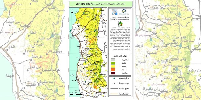
She explained that the platform presents “maps and risk spreading fire index” which contribute to providing data to forest departments and thus assist them in determining the priority of preparation and intervention in the sites with the highest risk of fires.
“The platform ‘s “Maps” identifies the areas which are most vulnerable to the outbreak of fire, based on the combined data of 9 basic factors that have been applied to forests in the governorates of Lattakia, Tartous, Hama and Homs as a first stage. The platform’s maps are due to be expanded to include all Syrian forests” Dr. Qarmoqa said. She referred that the “Fire Severity Index” of the platform depends on the climatic factors affecting the speed of the spread of fires such as temperature, wind speed and relative humidity.
Qaramouqa expressed her hope that the platform will contribute to alleviating the impact of fires in the coming days, and help the forestry teams on the ground in the efficiency of combating forest fire fighting.
Rawaa Ghanam