Emar… Ancient Near East Portal
The ancient near eastern town of Emar/Imar was situated on the middle Euphrates in northwest Syria, about 100 km east of Aleppo. Due to its geographical situation connecting Mesopotamia with the Mediterranean coast and with Anatolia, the town had a strategic function. Already the earliest mentioning in writing, namely in the palace archives of Ebla, ca. 2500 BC, and especially in the Mari texts from the 18th century BC, point to the town’s importance as traffic junction and contact zone between the Assyro-Babylonian and the Syro-Anatolian cultural spheres. Contrary to its importance as a commercial center, Emar was never the center of a superregional power
, but was rather awkwardly positioned between rivaling states. The history of Emar can be followed down to the middle of the third millennium BC, or, in archeological terms, down to the Early Bronze Age, when the town came under the influence of the rulers of Ebla and was mentioned in their archives at several instances.
Later news appear in the Mari texts (18th century BC, Middle Bronze Age) according to which Emar was under the influence of the neighboring state of Yamhad. For the 13th and the early 12th centuries BC (the Late Bronze Age), there is written documentation from Emar itself and also references in contemporaneous texts from Boazkoy/Hattuta, Ras Shamra/Ugarit and from Assyria. At that time, the town was part of the Hittite Empire, situated close to the frontier of the rivaling state of Assyria. Emar was subject to the king of Karkami, who represented the Hittite ruler in Syria, a member of the Hittite royal family and the connecting link between Hattua the Hittite capital in central Anatolia, and the Syrian (vassal states).
The Late Bronze Age town was excavated by a French team in the 1970s (see State of research).Occupation layers of the Middle and Early Bronze Ages were brought to light by recent Syrian- German excavations . Archeological as well as written documentation come to an end in the second third of the 12th century BC. The site was resettled on a larger scale in Byzantine times, only .
Up to now, we know of ca. 1,170 cuneiform texts from Emar. They are, with those from Ugarit, Mari and Ebla, among the most important tablet finds in Syria. About 800 texts come from the French excavations, the rest have turned up in the art market. The large majority is written in Akkadian. Besides, there are about 100 Hurrian texts (still unpublished) and two Hittite letters. Other than in the towns of Ugarit, Mari and Ebla, where most texts belong to the palace archives, the Emar texts have mainly been found in private houses.
They are, above all, judicial records – concerning, for example, dealings in real estate, marriages, last wills, adoptions -illustrating the private life of the population and, at the same time, showing the consequences of the Hittite conquest for the training of scribes and for society, in
general. In the house of a priest, the so-called Temple of Devin (M1), a library was found containing, besides literary and lexical texts in the Mesopotamian tradition, ritual texts for local cults. Particularly noteworthy is the ritual for the installation of the priestess of the weather god Ba’al of which there exist several copies.
State of research
In the 1970s, the Syrian Tabqa dam project was the reason for large-scale salvage operations in the middle Euphrates region. Salvage excavations on the site near modern Meskene, about 100 km east of Aleppo, were executed by two French teams between 1972 and 1976. Jean-Claude Margueron directed the excavation of the ancient near eastern town of Emar, while the exploration of Byzantine Barbalissos/Islamic Balis in the eastern part of the Tell was conducted by AndrÈ Raymond.
At Emar, the French archeologists discovered a temple area comprising the sanctuaries of the weather god Ba’al and – possibly of his consort Ashtarte as well as several dwelling-houses dating to the Late Bronze Age (13th and beginning of 12th century BC). From many excavation areas there came tablets, ca. 800 cuneiform texts, that were then published by the philologist Daniel Arnaud (Paris). Dominique Beyer (Strasbourg) examined the large amount of seal impressions on the tablets.
When the French excavations had come to an end, the site was left without a guardian. It was then systematically robbed leaving the place to look like a Swiss cheese and bringing new tablets onto the art market. In the meantime, ca. 370 texts from private collections in Lebanon, the US, Japan, and Israel have been published. In 1992, the Syrian Antiquities Department took charge of the site and began another round of scientific excavations under the direction of Shawki Sha’ath, archeologist, and Farouk Ismail, philologist. In 1996, a cooperation with the University of T¸bingen was brought under way, resulting, up to 2001, in four excavation seasons under the direction of Uwe Finkbeiner. Since 1999, the Syrian Antiquities Department has been represented by Jamil Massouh. Beside Late Bronze Age findings, the Syrian-German excavations unearthed occupation layers from the Middle and Early Bronze Ages (that is, from the second half of the third and the first half of the second millennium BC).
The Syrian-German excavations aimed first of all at establishing a topographical plan of the site, which should include those architectural findings of the French excavations that were still visible after the closing of the dam. About two thirds of the town are flooded. Today, the site is a peninsula along the southern bank of Lake Assad. It slopes from west to east. In the west, where the site is highest, there is a temple area with sanctuaries of the weather god Ba’al and, possibly of his consort Ashtarte. East of the temple area there is the so-called Upper Town with several excavated dwelling houses.
Bordering on the Upper Town, but in a pronounced depression and reaching all the way to the town-wall of Byzantine Barbalissos, there lies the so-called Lower Town. That is where the French archeologists excavated a temple (Temple M2) and a priest’s house (Temple of Devin, M1), which served also as training center for the religious elite of Emar and which harbored a large library. The most exciting tablet finds were made in that house. Besides literary and lexical texts in the Mesopotamian tradition they included ritual texts stemming from the local, Syrian sphere. A further dwelling-quarter in the north has survived as a small island. According to the French director, Jean-Claude Margueron, it harbored the residence of the king of Emar (“Bit- Hilani”). Fortunately, the destruction by looting that followed upon the end of the French excavations has only touched the uppermost, mainly Late Bronze Age layers.
The earlier layers in that part of the Tell that has not been flooded have remained accessible to further research. They stand at the beginning of the chronological presentation of the newest excavation
results:
The earliest findings up to this point were unearthed beneath the temple of Ba’al and the courtyard east of it. In three building levels following close one upon the other, Early Bronze Age dwelling-houses are more or less well preserved. The two later levels are disturbed by the foundations of the temple, which reach that far down. So far, the earliest level has yielded a small room (ca. 2 x 2.5 m). Its walls are made of pisÈ mixed with pebbles and covered with a thin layer of mud and lime. It contained a large and varied inventory that was crushed in situ on the floor. The inventory comprises clay vessels as well as (the upper parts of) terracotta figurines and jewelry made of mother-of-pearl and of bone.
Middle Bronze Age, the next younger period, was ascertained in the southwest, at the highest elevation of the town, as well as in the so-called Upper Town. It shows in a piece of the town wall with bastions and, right to the east of it, under the temple of Ashtarte, in a courtyard with fireplace, tannurs and post-holes for a roof.
Three solid floors on top of one another stand for three usage levels, but it remains uncertain whether the courtyard was part of a dwelling-place or of a defensive installation – easy to imagine in view of the situation, so exposed and bordered by the town-wall with a width of two and a half meters.
The dwelling-houses that were excavated in the Upper Town belong to the Middle and Late Bronze Ages. A house, dating to around 1400 BC is particularly noteworthy.
Its ground-plan is a combination of two Middle Bronze Age standard ground plans dividing the house into a western and an eastern group of rooms. The finds suggest that in the western rooms, bones were worked while the eastern rooms served to process grain. In the west, several animal horns and two jawbones of elephants were found, while the assumed function of the eastern rooms is supported not only by appro appropriate tools but also by a clay tablet listing rations of grain.
From the debris above the house, there emerged a silver stamp-seal, very well preserved. It bears an inscription in Luwian hieroglyphs giving the name of its owner as Kuku. The seal is certainly later than the house; it may have come to Emar around the 13th century BC, at the time of Hittite hegemony.
Other Late Bronze Age finds from the Upper Town include terracotta figurines (animals, naked women holding their breasts, a musician) and a clay object of unknown function, moulded in the negative and showing motifs from the Mesopotamian, Anatolian and Syros- Palestinian repertoires. As to the Late Bronze Age, we concentrated on the temple area, as had the French archeologists before us.
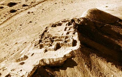
The temple area in the very west of the hill that is the Emar of today, consists of the sanctuaries of Ba’al and, possibly, of Ashtarte as well as of courtyards and a cult terrace; it is enclosed by a strong wall.
The temple of Ba’al is an antae temple situated on a terrace which may be gained from the lower courtyard by a flight of stairs. Two building-phases can be differentiated: A smaller installation (7.5 x 14.5 m) was superstructed by a larger one (11.5 x 20 m).
During excavation
The temple of Ashtarte has two phases as well. But here it seems as if the earlier installation was larger, while ground-plan and dimensions of the later one resemble the earlier temple of Ba’al. Again, a flight of stairs must have led up to the terrace.
The earlier sanctuaries were destroyed by fire. There is a broad road running between the two temples, which, at several instances, has been coated with a covering of mud and lime. The road may have led processions up from the lower courtyard to the so-called cult terrace in the extreme west. Originally, the way up from the lower courtyard via the flight of stairs to the temple of Ba’al was decorated with two lion sculptures. The torso of one lion was still lying in the courtyard; the carving at the front and on only one side showed that the lion was incorporated at a place where only one side was visible. This particular lion had lost its head, only, whereas its counterpart and a pair of smaller lions were stolen en bloc and offered on the art market.
Other finds come from tombs that were brought down here in Late Roman times. More than thirty were laid bare, almost all of them had been looted. The grave-gifts that were – luckily – overlooked include a bronze fibula and a small facetted glass bottle that could be completely restored. Barbalissos – The restoration According to archeological as well as to written material, the history of the ancient town of Emar came to an end in the first third of the 12th century BC.
Many centuries passed before life stirred again in the ruins of Emar, presumably in Achemenian times. Apart from a Corinthian capital that came down to us as spoil we know about the Achemenian town of Bala or about the later Hellenistic and Roman towns only from texts. A change comes in Byzantine times. Justinian II let the eastern boundaries of his empire be secured by fortresses and the town that was now called Barbalissos be surrounded by strong walls. In the west, where the land rises and is most open to possible attacks, two mighty corner towers were added, spacious enough to house the guards and, at 25 meters, high enough to allow a far view into the Euphrates valley. Due to its elevated position, this western part of the town-wall has survived to this day. The ruins of the southwestern corner tower and of the so-called praetorian in the north are still an impressive landmark that is visible from afar. But with the winter storms, the lake continued to erode the banks and seriously threatened the existence of this cultural monument.
In this precarious situation, the German Ministry of Foreign Affairs came to the rescue and granted means with which the southwest tower was secured in 2000, already. In the first place, an access had to be prepared; for about half of its length, it is a dam newly piled up along the southern bank. The tower itself got a new foundation consisting of 90 m3 of cement; the facade was covered with original tiles gathered in the ruin.
The next object to be salvaged was the praetorium two walls of which – ruined but still 20 meters high – form the northwestern corner. Here, too, the further existence of the ruin was endangered by a deep gap in the corner. In the summer of 2001, the debris sloping in front of the wall was removed so that it was easier to estimate the extent of the damage. It became obvious that the western wall with its embrasures was almost completely intact.
In the summer of 2002 and again with the financial support of the Ministry of Foreign Affairs, the northern bank was strengthened, the dangerous gap at the corner of the praetorium was filled and the facade covered with tiles baked in the traditional way. At the same time, the documentation of the ruin, financed by the University of T¸bingen, was completed: an object of cultural heritage has been preserved, in reality and in scientific documentation.
Haifaa Mafalani